Isle of Man
History & Culture:
Rich in history, the Isle of Man can look back on a tapestry of events from
the introduction of farming in the fourth millennium BC, the Manx Iron Age
from 500 BC to 500 AD, the Celtic traditions, through to Christianity and
Viking rule of the ninth century. During the mid-thirteenth to early fifteenth
centuries, Sovereignty passed frequently between Scotland and England, with
occasional incursions from Ireland. Throughout the centuries the Isle of Man
has developed a way of life and a culture all of its own. Many world events
such as the Roman and Norman invasions of Britain passed it by and the Island
quietly took visits from Irish and Scottish freebooters in its stride. The
arrival of the Vikings however, did leave a lasting mark on this tiny Celtic
nation. After a period of turbulence the Celts and Vikings came together as
one nation and without a doubt the greatest single gift left by these fearsome
Northern warriors was a unique system of Government that exists to the present
day - Tynwald.
Location:
The Isle of Man is located in the middle of the Irish Sea, 83 miles from Liverpool
and 90 miles from Belfast and is approximately 221 miles or 572 kilometres
square, being 32.5 miles (50 kilometres) long from north to south and 13.5
miles (20 kilometres) wide from east to west. Scenically it has a little of
everything that is attractive about the British Isles - a central mountain,
Snaefell (2,036 feet or 620 metres), surrounded by hills that lead down to
seventeen national Glens, fertile farmland and a varied coastline.
Population:
The Island's resident population numbered 76,535 in September 2001 - roughly
half being Manx born and the rest largely British, although an increasingly
varied mix of nationalities are moving here to work in the financial and service
industries. The capital town is Douglas, the seat of the Manx Government and
main centre of population (25,308). Other major settlements are Onchan (8,706),
Ramsey (7,626), Peel (3,779), Port Erin (3,351), Castletown (3,082) and Port
St Mary (1,927). New housing in estates and village outskirts is gradually
changing the traditional look of the Island but there is still plenty of 'green'
space and quiet, unspoilt countryside. Just off the southern tip of the Island
lies a two square kilometre islet called the Calf of Man, an offical Bird
Sanctuary which is owned by the Manx National Trust. The Calf's only year-round
resident is a warden but it is open to public visits during the summer.
Weather:
The Island typically enjoys 'British' weather tempared by the effects of the
Gulf Stream that runs through the surrounding Irish Sea. Exposure to sea breezes
keeps average summer temperatures in the early to mid twenties centigrade,
while winters tend to hover around 9 degrees and snow sometimes strikes in
late February/ early March. The thick sea fog that occasionally smothers the
island's lowland areas is known locally as Manannan's Cloak, a reference to
the Island's ancient Sea God swathing his kingdom in mist to protect it from
unwanted visitors.
Political status:
The Isle of Man has the unusual status of being one of the British Isles that
is neither part of Great Britain nor the United Kingdom. People born here
are known as 'Manx', classified as British (as opposed to English). Despite
the steady integration of new residents from other countries, some locals
still refer to newcomers as 'comeovers' and England as 'across'. The Queen
is the Island's constitutional head of state - the Lord of Mann - and she
is represented here by a resident Lieutenant Governor (currently Air Marshall
Ian MacFadyen). The IOM is not a full member of the European Union but has
associate status. This allows Island-traders free trade with the rest of the
community but means we're not liable for financial contributions nor eligible
for EU grants. The IOM is not represented in the UK parliament as it has its
own parliament - the Tynwald, an institution founded by the Vikings over a
thousand years ago.
English is the first language of modern Manx people but the 'old' language
is Manx Gaelic. There are no longer any native Manx speakers but a growing
number of enthusiasts have kept it alive and it is a learning option for all
schoolchildren over the age of 7. Government departments use English and Manx
titles on all official documents, correspondence and vehicles and Manx is
also used on town and road signs and increasingly by commercial businesses.
Common Gaelic place names include Beg (little), Balla (place, farm or home
of), Creg (rock), Bayr (road), Purt (harbour), Cronk (hill). Norse place names
include the use of fell (mountain), rick/wick (cove or bay), howe (hill) and
ayre (gravel beach). The Manx National Flag comprises the white, grey and
yellow 'Three Legs' set against a red background. It is flown by many residents
at the time of the Manx National Holiday, - Tynwald Day, on July 5th. On this
day, new laws are publicaly promulgated on the ancient Tynwald Hill at St
Johns - a ceremony that dates back to Viking times. The National Symbol is
the Three Legs of Man, first officially used in the early fourteenth century
on the Manx Sword of State. The legs, clad in armour and bearing spurs, run
in a clockwise direction and bear the Latin motto 'Quocunque Jeceris Stabit'
or 'Whichever way you throw it, it will stand' - a testament to islanders'
independence and resilience. The Three Legs also appear on the Manx Coat of
Arms, flanked by a Peregrine Falcon and a Raven. The source of the legs emblem
is subject to many theories including the legend of the Island God Manannan,
who is said to have set fire to the Legs in a fit of rage and hurled them
down the hill in a burning wheel. The Legs are also related to Sicily's emblem
of three naked legs surrounding the head of Medusa, and the swastika, both
of which can be traced back to pagan symbols representing the Sun.
SKINNER FAMILY
The Skinner family originated in the Isle of Man in the parish of Andreas.
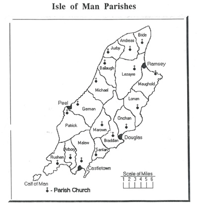
ANDREAS
THE parish of Andreas stretches from thc Lhen Moar for four miles along the north-western coast, to within three miles of the Point of Ayre, and is bounded on the south by the parish or Lezayre. Towards the east it is separated from the parish or Bride by an irregular boundary line. It contains about 15 square miles. In appearance and character it is similar to the adjoining parishes, and in fact it forms a part of the great Sandy plain of the Curragh. Its northern parts are crossed by a range or low, rounded sandhills, which extend from Port Cranstal to Blue Head. It is a purely agricultural district, and contains a considerable scattered population.
Kirk Andreas - St Andrew Church
Built 1802 using stone from Sulby Glen A 120 ft bell tower linked to the church by an arch was added in 1869 but top hair was removed during WW2 by the Air Ministry in order to improve safety at the nearby airfield. Although money was allocated to rebuild it after the war the palish decided it had more pressing demands to satisfy.
The links below are support documents from the Isle of Man that support the family history information provided.
lsle Man Skinner Marriages and Baptisms 1600-1900
lsle Man Skinner Burials 1600-1900
lsle Man Parish Bride Skinner Records